Fira
The capital of Santorini
The capital of Santorini
To the west below Fira, there is Gialos (the old port) where the cruisers make ports and the cable car transfers visitors to the capital.
Almost connected to Fira is Firostefani.
During winter (for the locals) and summer (for the thousands of visitors), Fira is the epicenter of social life, entertainment, shopping. Hotels, rooms to let, clothing and accessories shops, goldsmith’s stores, galleries, gift shops, super markets, groceries, banks and ATMs, pharmacies, bars, clubs, restaurants, travel agencies are located in the capital.
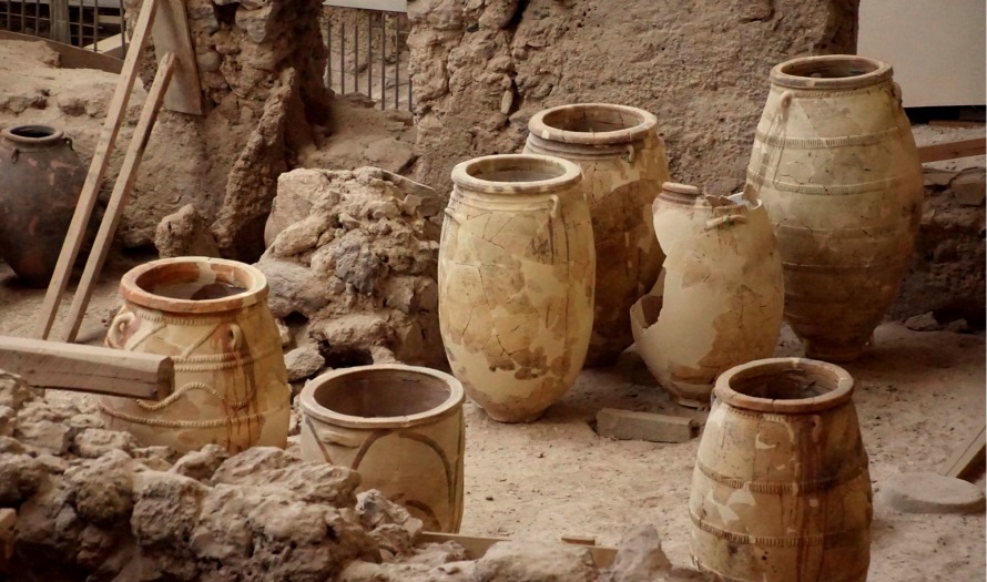
Here you will find some of the most important museums of the island such as the museum of Prehistoric Thera and the Archeological. You will also find among others Megaro Gyzi, the P. Nomikos Conference Center, the Santozeum housing the murals of Akrotiri, Belonio Cultural Center, and Emm. A. Lignos’s Folklore museum.
The epicenter in the side of Caldera is the area around the Orthodox Cathedral. Outside of the Caldera most visitors will pass through the busy Theotokopoulos square where shops and banks are located. Also located near the square are the bus and taxi starting points. March 25th st. found here leads to Firostefani, Imerovigli, Oia.
On the opposite side there is the main road leading to Pyrgos, Athinios, Megalohori, Akrotiri village and Akrotiri archaeological site, Emporio, as well as the beaches of the south and the south-east side of the island.
The name Fira is considered to be a corruption of the word Thera. The original site of the settlement was the Goulas (tower) of the Bozzi family. The tower had defensive battlements and embrasures above the entrance for the fear of invaders.
According tο Dr Dora Monioudi-Gavala, in the 1745 drawing by Barskij, the Goulas appears, the name “Fyra” marked by him defines the place, but there is no settlement. In the position Fira takes place today, there used to be vineyards and kanaves (wine storing rooms), where wine was produced and where they lived during the summer.
In late 18th century, people from Skaros castle (the capital of the island until then), as well as from other castles and villages, resettled here. As I. Delendas comments “…Both populations, Orthodox and Roman Catholics, convened and agreed on the need of a new capital, a new city suitable to the novel demands life presented them with. They could not stay and, what is more, there was no reason any longer for their remaining secluded in towers and castles…Moreover, Fira’s position is most recommended for the new city, due to the fact that it lies near the port through which the island communicates. Since the end of the 18th century Fira has ceased to the regarded as a simple settlement. Many comfortable for the time buildings have been constructed…The more progress Fira makes, the more Skaros becomes deserted. Everything in the old castle witness abandonment. From most houses floors, frames and whatever can be used elsewhere has been removed…”.
The town belongs to the type of linear settlements, as it developed along a main axis towards the mouth of the Caldera, clustering around Catholic and Orthodox churches and monasteries according to the origin of the population but without any planning as far as quarters were concerned. Round the point where the circulation axis constructed with steps leading from the port to the town ended there was created a market place. The Catholics took up residence in an area called Fragomachalas (neighborhood of the Franks), in the north side of the village.
Buildings that stood in Fira until the 1956 earthquake dated back to late 18th century. That is when Vincentian, Lazarist, and Dominican monasteries were built, along with the Cathedral of Saint John the Baptist. According to Dr Dora Monioudi-Gavala “other important buildings were the orthodox Cathedral –Holly Virgin of Bellonias- the Archaeological museum, the building of the eye-hospital of Thera “St Barbara” and several dwellings. The social status of the owners of the latter led to differences in size, the multiplicity of space and the equipment that could be found either inside or outside them”.
The area where the Orthodox Cathedral of Hypapante Sotira (the Reception of Christ) is located, is always filled with people, especially during sunset. The initial temple was built by Theran merchant M. Blelonias, who brought a Byzantine icon which, according to tradition, originated in Aghia Sophia of Constantinople. The small private temple had been demolished in 1901. A bigger one took its place, but it sustained great damage during the 1956 earthquake so it had to be demolished too. The present church, designed by George Nomikos, had been built in its place between 1963-1968.
Opposite the Cathedral is a very popular spot of Fira called boudi (low wall), where visitors stop to admire the view and take photos. Walking on the left (as you face the volcano) you will discover Kato (Lower) Fira, a beautiful, quiet neighbourhood built around the churches of Aghios Ioannis (St John, Farm of the monastery of St John in Patmos) and Aghios (St) Minas.
From the Cathedral you will walk to the right on Ipapantis street which is also called Gold Street, taking its name after the goldsmith’s stores. Further down this street is the busier and more vibrant area of the capital, filled with all sorts of shops, cafes, bars, restaurants etc. You will reach the area where the Archeological museum and the cable car are located: Here is another popular spot to admire the sunset and take photos of the impressive settlement and the volcano.
From then on, always on foot, you will pass by Petros Nomikos Conference Centre and get to Firostefani.
In the area of Fragomahalas, in the north side of Fira, you will admire the imposing houses of the old Catholic families, where grand musical evenings were organized in the 19th century, the Cultural Center Megaro Gyzi, the Catholic Cathedral, the Lazarist monastery, and the monastery of Dominican Nuns and Sisters of Mercy, built in 1841. The later two as well as the monastery of Dominican nuns have not been operational since the 1956 earthquake.
The impressive neoclassic building that houses Petros Nomikos Conference Centre is located in Nomikos street. Distinguished on top is the restored Goulas of Fira, property of Petros M. Nomikos
In the old days, Gialos (the old port) was connected to Fira only by the so called “Karavolades” stairs. The cable car, built upon funding by ship owner E. Nomikos in 1982, solved the problem of transportation. Shipowner Evangelos Petrou Nomikos, with Messaria and Fira origin, funded the construction of the cable car which started operating in 1982.
The benefactor spent 144.000.000 Greek drachmas. The purpose of the project was to be for public benefit and all the revenue generated would go to the communities of the island*. In the present day the revenue generated go to the Municipality of Thira, and is also financially supporting the mule drivers. The cable car can carry up to 1,200 passengers per hour.
To the west below Fira, there is Gialos (the old port) where the cruisers make ports and the cable car transfers visitors to the capital.
Almost connected to Fira is Firostefani.
During winter (for the locals) and summer (for the thousands of visitors), Fira is the epicenter of social life, entertainment, shopping. Hotels, rooms to let, clothing and accessories shops, goldsmith’s stores, galleries, gift shops, super markets, groceries, banks and ATMs, pharmacies, bars, clubs, restaurants, travel agencies are located in the capital.
Here you will find some of the most important museums of the island such as the museum of Prehistoric Thera and the Archeological. You will also find among others Megaro Gyzi, the P. Nomikos Conference Center, the Santozeum housing the murals of Akrotiri, Belonio Cultural Center, and Emm. A. Lignos’s Folklore museum.
The epicenter in the side of Caldera is the area around the Orthodox Cathedral. Outside of the Caldera most visitors will pass through the busy Theotokopoulos square where shops and banks are located. Also located near the square are the bus and taxi starting points. March 25th st. found here leads to Firostefani, Imerovigli, Oia.
On the opposite side there is the main road leading to Pyrgos, Athinios, Megalohori, Akrotiri village and Akrotiri archaeological site, Emporio, as well as the beaches of the south and the south-east side of the island.
The name Fira is considered to be a corruption of the word Thera. The original site of the settlement was the Goulas (tower) of the Bozzi family. The tower had defensive battlements and embrasures above the entrance for the fear of invaders.
According tο Dr Dora Monioudi-Gavala, in the 1745 drawing by Barskij, the Goulas appears, the name “Fyra” marked by him defines the place, but there is no settlement. In the position Fira takes place today, there used to be vineyards and kanaves (wine storing rooms), where wine was produced and where they lived during the summer.
In late 18th century, people from Skaros castle (the capital of the island until then), as well as from other castles and villages, resettled here. As I. Delendas comments “…Both populations, Orthodox and Roman Catholics, convened and agreed on the need of a new capital, a new city suitable to the novel demands life presented them with. They could not stay and, what is more, there was no reason any longer for their remaining secluded in towers and castles…Moreover, Fira’s position is most recommended for the new city, due to the fact that it lies near the port through which the island communicates. Since the end of the 18th century Fira has ceased to the regarded as a simple settlement. Many comfortable for the time buildings have been constructed…The more progress Fira makes, the more Skaros becomes deserted. Everything in the old castle witness abandonment. From most houses floors, frames and whatever can be used elsewhere has been removed…”.
The town belongs to the type of linear settlements, as it developed along a main axis towards the mouth of the Caldera, clustering around Catholic and Orthodox churches and monasteries according to the origin of the population but without any planning as far as quarters were concerned. Round the point where the circulation axis constructed with steps leading from the port to the town ended there was created a market place. The Catholics took up residence in an area called Fragomachalas (neighborhood of the Franks), in the north side of the village.
Buildings that stood in Fira until the 1956 earthquake dated back to late 18th century. That is when Vincentian, Lazarist, and Dominican monasteries were built, along with the Cathedral of Saint John the Baptist. According to Dr Dora Monioudi-Gavala “other important buildings were the orthodox Cathedral –Holly Virgin of Bellonias- the Archaeological museum, the building of the eye-hospital of Thera “St Barbara” and several dwellings. The social status of the owners of the latter led to differences in size, the multiplicity of space and the equipment that could be found either inside or outside them”.
The area where the Orthodox Cathedral of Hypapante Sotira (the Reception of Christ) is located, is always filled with people, especially during sunset. The initial temple was built by Theran merchant M. Blelonias, who brought a Byzantine icon which, according to tradition, originated in Aghia Sophia of Constantinople. The small private temple had been demolished in 1901. A bigger one took its place, but it sustained great damage during the 1956 earthquake so it had to be demolished too. The present church, designed by George Nomikos, had been built in its place between 1963-1968.
Opposite the Cathedral is a very popular spot of Fira called boudi (low wall), where visitors stop to admire the view and take photos. Walking on the left (as you face the volcano) you will discover Kato (Lower) Fira, a beautiful, quiet neighbourhood built around the churches of Aghios Ioannis (St John, Farm of the monastery of St John in Patmos) and Aghios (St) Minas.
From the Cathedral you will walk to the right on Ipapantis street which is also called Gold Street, taking its name after the goldsmith’s stores. Further down this street is the busier and more vibrant area of the capital, filled with all sorts of shops, cafes, bars, restaurants etc. You will reach the area where the Archeological museum and the cable car are located: Here is another popular spot to admire the sunset and take photos of the impressive settlement and the volcano.
From then on, always on foot, you will pass by Petros Nomikos Conference Centre and get to Firostefani.
In the area of Fragomahalas, in the north side of Fira, you will admire the imposing houses of the old Catholic families, where grand musical evenings were organized in the 19th century, the Cultural Center Megaro Gyzi, the Catholic Cathedral, the Lazarist monastery, and the monastery of Dominican Nuns and Sisters of Mercy, built in 1841. The later two as well as the monastery of Dominican nuns have not been operational since the 1956 earthquake.
The impressive neoclassic building that houses Petros Nomikos Conference Centre is located in Nomikos street. Distinguished on top is the restored Goulas of Fira, property of Petros M. Nomikos
In the old days, Gialos (the old port) was connected to Fira only by the so called “Karavolades” stairs. The cable car, built upon funding by ship owner E. Nomikos in 1982, solved the problem of transportation. Shipowner Evangelos Petrou Nomikos, with Messaria and Fira origin, funded the construction of the cable car which started operating in 1982.
The benefactor spent 144.000.000 Greek drachmas. The purpose of the project was to be for public benefit and all the revenue generated would go to the communities of the island*. In the present day the revenue generated go to the Municipality of Thira, and is also financially supporting the mule drivers. The cable car can carry up to 1,200 passengers per hour.
*Data are from the text of economist Eleftherios Gyzis, in the book “Santorini: Thera, Therassia, Aspronisi, Volcanoes, of Ioannis M.Danezis/2001, Editor in chief Emm. A. Lignos.